North of Beaver Meadow Road
- Parcel 5
- Brookmead Conservation Area
- Blue Ribbon Trail
- Blue Ribbon Connector
- Gile Mountain Area
- Bradley Hill Trail
Return to Summary
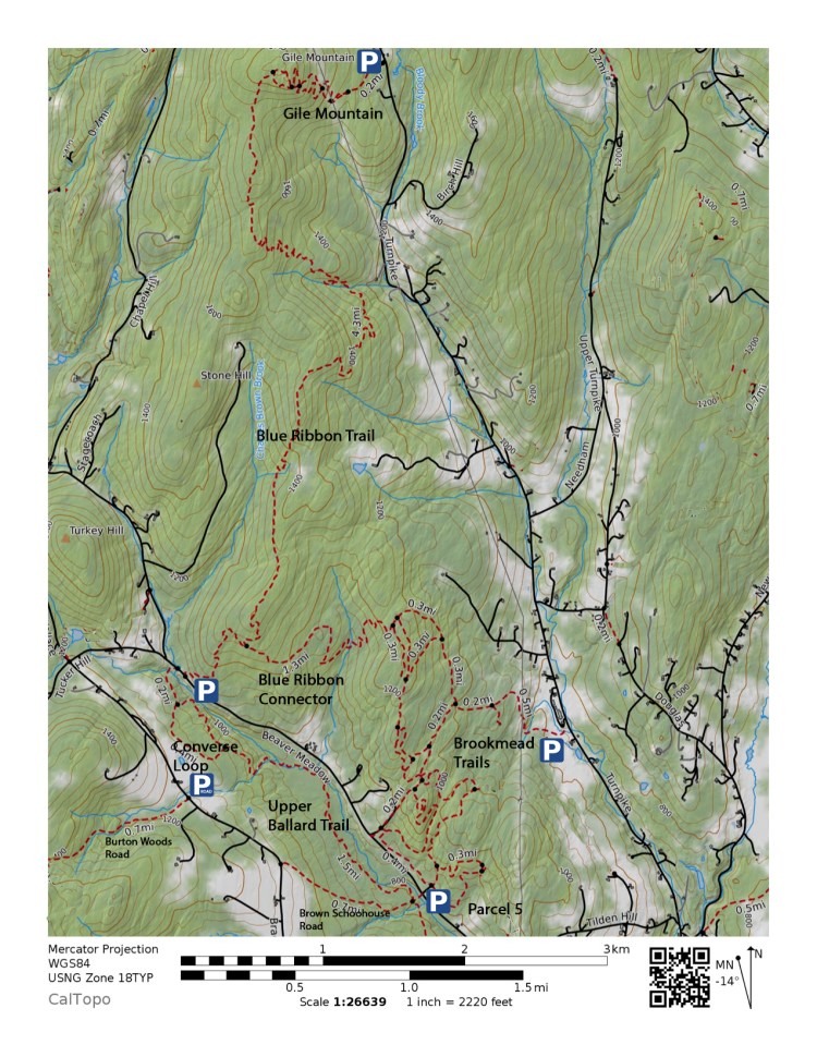
Parcel 5 [Map] [Trail Finder]
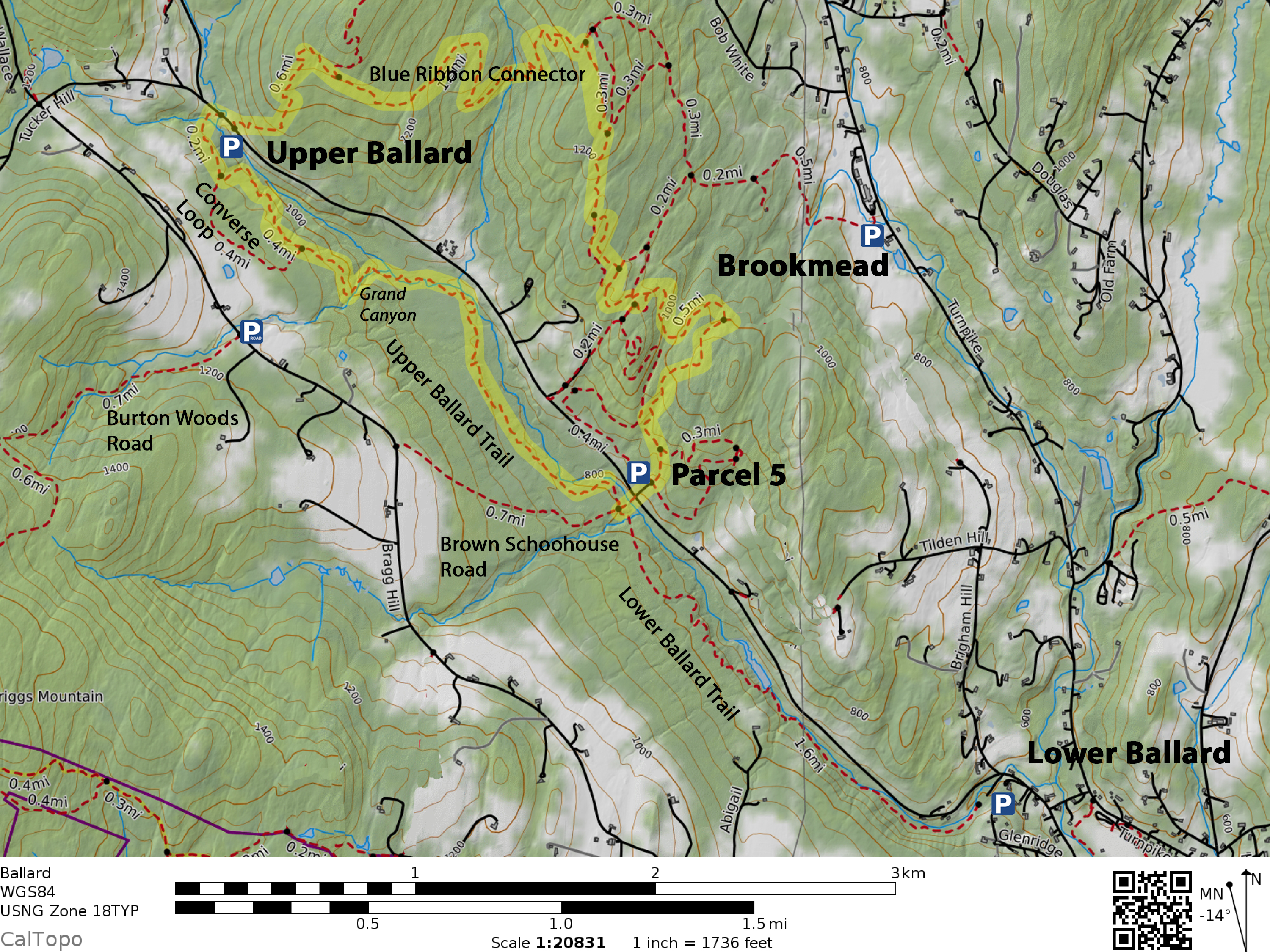
Overview: Parcel 5 is a part of the Norwich Fire District, and is laced with a network of trails suited for running, mountain biking and skiing. The main trail has 2 major lobes, one approximately 3 km, the other 2 km. It features several shortcuts, as well.
The first map has been updated to show several trails constructed in 2020-21. Near the top of the main trail, a new connector drops down to the Brookmead trail system, primarily for skiers and grooming equipment to flow between the two systems. Two new trails intended mainly for mountain biking are shown with blue dots: Just W of the trailhead, a new flow trail P5 Fo Fun, allows most riders to climb gently up to the top of the parcel. Just before it joins the top of the main trail, Dole It Out branches S, providing a more challenging descent that rejoins the main trail lower down.
Connections: Via shortcuts, 0.7 miles to the Brookmead Trail system.
Lengths: 3.1 mi. (Main Loop); 1.1 mi. (P5 Fo Fun); 0.25 mi (Dole It Out).
Directions to trailheads: Parcel 5 is 2.5 miles up Beaver Meadow Road from the Norwich Inn. Look for a driveway with a small sign that says, “5” on the right.
Parking: Parcel 5 parking has ample space for multiple vehicles.
Markings: None, trails are distinct with maps at intersections.
Hikes using this trail: Ballard-Blue Ribbon, a 5.5-mile loop
Brookmead Conservation Area [Map] [UVLT map]
Overview: The Upper Valley Land Trust‘s Brookmead Conservation Area, located on Turnpike Road, offers several miles of multi-use trails, with connections to Parcel 5 and Blue Ribbon Connector trails.
Connections: Refer to the map for trail lengths. Measured from parking, an approach trail passes a dead-end trail to a cabin (0.5 mi.) and meets a system of loops (0.7 mi.), turning right on the outer-most loop, the northern-most lobe connects to the Blue Ribbon Connector Trail (1.3 mi.), continuing on the outer-most loop, the southern-most lobe connects to the Parcel 5 trails (2.1 mi). Returning to parking, the loop meets the approach trail (2.4 mi.) and the parking area (3.1 mi.). There are a variety of internal connecting trails, along the way.
Length: 3.1 miles, outer loop, plus 1.1 miles of connecting trails
Directions to trailhead: Brookmead trailhead is 2.8 miles from the Norwich Inn, via north on Main Street (0.5 mi.), turning left on Turnpike Road (2.8 mi.) to trailhead on left
Parking: Brookmead parking has ample room for vehicles, parked face in.
Markings: Trails are marked with blue blazes and silver disks with trail maps at intersections, marked to show location.
Hikes using this trail: Ballard-Blue Ribbon, a 5.5-mile loop
Blue Ribbon Trail [Map]
Overview: A multi-use trail between Gile Mountain summit and Beaver Meadow Road. While mostly running along the ridgetop, there is one descent in the middle which requires a significant climb back up to the ridge.
Connections: From Beaver Meadow Road to Blue Ribbon Connector Trail (0.6 mi.) to Gile Mountain Summit (+4.2 mi.—4.8 miles cumulative), to Gile Mountain parking lot (+0.7 mi. —5.5 mi. cumulative via the hiking trail).
From Gile Mountain parking lot to Gile Mountain Summit and Blue Ribbon Trail junction (0.7 mi. via the hiking trail) to Blue Ribbon Connector Trail (+4.2 mi.—4.9 miles cumulative), to Beaver Meadow Road (+0.6 mi.—5.5 miles cumulative).
Length: 4.8 miles from Beaver Meadow Road to Gile Mountain summit
Directions to trailheads:
- Upper Ballard trailhead is 3.9 miles up Beaver Meadow Road from the Norwich Inn. Look for a widened area on the left, just before Tucker Hill Road.
- Gile Mountain trailhead is 5.7 miles from the Norwich Inn, via north on Main Street (0.5 mi.), turning left on Turnpike Road (5.2 mi.) to trailhead on left. If the parking lot is full, wait for a space.
Parking:
- Upper Ballard parking has sufficient space for multiple vehicles, parked face in.
- Gile Mountain parking has room for about five vehicles, parked face in. Vehicles parked in the road are subject to ticketing.
Markings: Blue
Hikes using this trail: Ballard-Blue Ribbon, a 5.5-mile loop
Blue Ribbon Connector [Map]
Overview: A multi-use trail between the Brookmead Trail system and Beaver Meadow Road (via the Blue Ribbon Trail)
Connections: From Beaver Meadow Road via Blue Ribbon Trail to Blue Ribbon Connector Trail (0.5 mi.) to Brookmead Trail system (1.3 mi.).
Length: 1.3 miles
Directions to trailheads:
- Upper Ballard trailhead is 3.9 miles up Beaver Meadow Road from the Norwich Inn. Look for a widened area on the left, just before Tucker Hill Road.
- Brookmead trailhead is 2.8 miles from the Norwich Inn, via north on Main Street (0.5 mi.), turning left on Turnpike Road (2.8 mi.) to trailhead on left.
Parking:
- Upper Ballard parking has sufficient space for multiple vehicles, parked face in.
- Brookmead parking has ample room for vehicles, parked face in.
Markings: Blue
Hikes using this trail: Ballard-Blue Ribbon, a 5.5-mile loop
Bradley Hill Trail [Map]
Overview: Connects Bradley Hill Road on the south with Kerwin Hill and Ladeau Roads on the north.
Connections: From Bradley Hill Road to a fork (0.6 mi.), leading to the top of Kerwin Hill Road (0.1 mi., right) and Ladeau Road (0.1 mi., left).
Length: 0.6 miles
Directions to trailheads:
- Bradley Hill Road trailhead measured from the Norwich Inn, head north on Main Street (0.6 mi.), which turns into Union Village Road. Continue until Bradley Hill Road on the left (2.2 mi.). Follow Bradley Hill Road until Powers on the right (4.2mi.). Park on the roadside near powers, being careful not to block driveways or gates. Walk/cycle to trailhead at end of Bradley Hill road (4.4 mi.).
- Kerwin Hill trailhead (no parking available) measured from the Norwich Inn, head north on Main Street (0.6 mi.), which turns into Union Village Road. Follow Union Village Road to Rte 132 (5.3 mi.), turning left onto Kerwin Hill Road (5.9 mi.). Follow Kerwin Hill Road to the end (7.2 mi.). Walk or cycle to the trailhead on the left (7.4 mi.).
- Ladeau Road trailhead (no parking available) measured from the Norwich Inn, head north on Main Street, turning left on Beaver Meadow Road (0.5 mi.). Follow Beaver Meadow Road to turn right onto New Boston Road (1.5 mi.). Follow New Boston to right onto Norford Lake Road (4.1 mi.). After 200 ft, turn right onto Ladeau and follow it to the end (4.7 mi.). The trailhead is on the right (4.8 mi.).
Parking:
- Bradley Hill Road parking is roadside near Powers Road. Be careful not to block the traveled lanes, driveways or gates.
- Kerwin Hill parking may be available along the road, where it’s possible not to block the traveled lanes.
- Ladeau Road parking may be available along a nearby road, where it’s possible not to block the traveled lanes.
Markings: The trail is marked with a sign at the southern end.
Hikes using this trail: Bradley-Kerwin-Patrell, a 4.1-mile loop
