South of Beaver Meadow Road

- Appalachian Trail
- Heyl Trail
- Tucker Trail
- Cossingham Trail
- Burton Woods Road
- Town Highway 51
- Ballard Trail
- Converse Loop Trail
- Brown Schoolhouse Trail
Appalachian Trail [Map]
Overview: Runs east and west through a federally protected corridor, managed by the Green Mountain National Forest (US Park Service) and maintained by the Green Mountain Club. The eastern terminus in Norwich is at the Ledyard Bridge, crossing the Connecticut River. The western terminus in Norwich is on Podunk Road, where it continues to West Hartford to cross the White River via roads.
Connections: Mileages from the Ledyard Bridge to the bottom of Elm Street (0.9 miles), left to the top of Elm Street (1.9 miles to the entrance to the corridor), to the VELCO power line (2.7 miles), Cossingham Trail (3.7 miles), Tucker Trail (4.9 miles), Town Highway 51 (6 miles), Podunk Road (7 miles), where one crosses into Hartford.
Length: 7 miles
Directions to trailheads:
- Elm Street leaves Main Street opposite the bandstand at the Marion Cross School playground. Proceed 0.9 mi. to the end and turn around to parking.
- Cossingham Road is reached via Beaver Meadow Road, 0.4 mi from the Norwich Inn to Bragg Hill Road on left, 1.3 miles to Cossingham Road on left. 100 yds to parking.
- Happy Hill Road is reached just beyond Cossingham Road on the left. Drive 0.7 miles to the turnaround and park.
Parking:
- Elm Street parking is on the shoulder of the road. In wintertime, be sure to park out of the traveled lanes, especially to allow passage of emergency vehicles.
- Cossingham Road parking is front or back in to allow for efficient accommodation of multiple vehicles. Please be considerate to nearby neighbors by keeping voices low and dogs on leash between the parking area and the AT intersection. Also, there are electric fences and farm animals along this stretch of the trail.
- Happy Hill Road parking accommodates four to five vehicles, backed in. Be sure to keep all gates and driveways unblocked. In winter allow room for the snowplow to turn around.
Markings: White blazes
Hikes using this trail:
- Heyl-AT from Elm, a 1.2-mile out-and-back
- Cossingham-Tucker, a 3.1-mile loop
- Heyl-AT from Pizza oven, a 3.7-mile loop
- Burton-Tucker, a 6.0-mile loop
- Cossingham-Burton, a 6.7-mile loop
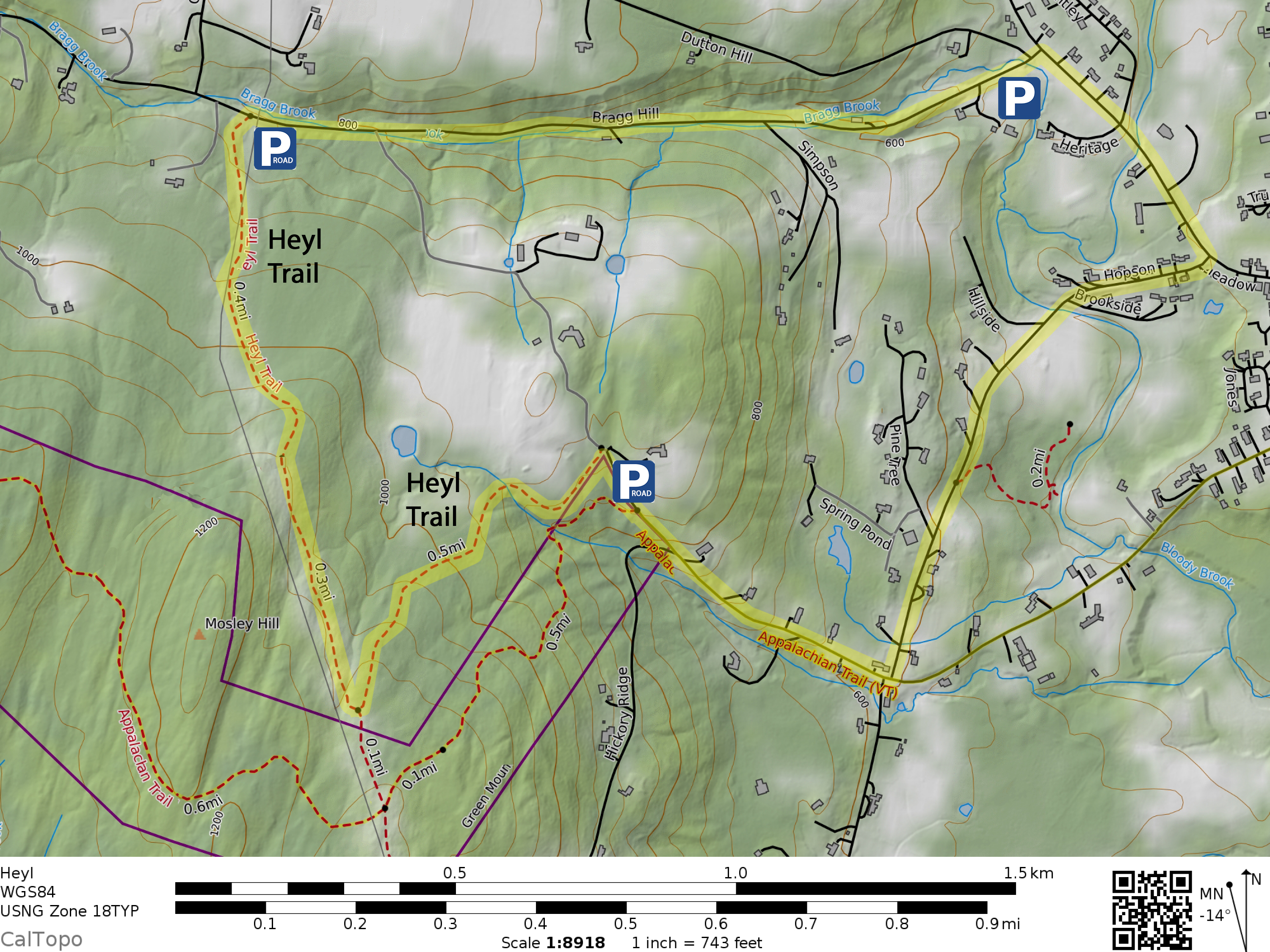
Heyl Trail [Map]
Overview: Connects the top of Elm Street to the VELCO power line easement via the power line road to Bragg Hill.
Connections: From the top of Elm to the power line is 0.4 miles. From Bragg Hill Road to the same point is 1.1 miles.
Length: 1.5 miles
Directions to trailheads:
- Elm Street leaves Main Street opposite the bandstand at the Marion Cross School playground. Proceed 0.9 mi. to the end and turn around to park.
- Bragg Hill Road is reached via Beaver Meadow Road, 0.4 mi from the Norwich Inn to Bragg Hill Road on left, 0.9 miles to where the power line crosses overhead.
Parking:
- Elm Street parking is on the shoulder of the road. In wintertime, be sure to park out of the traveled lanes, especially to allow passage of emergency vehicles.
- Bragg Hill Road parking is roadside under the power lines, across from the trail. Keep the power line access road gate clear.
- Additional parking is at the Barrett Park area with the pizza oven at the bottom of Bragg Hill Road—a 0.9-mile walk to the trail.
Markings: Signs at Elm Street, VELCO power line, and Bragg Hill Road
Hikes using this trail:
- Heyl-AT from Elm, a 1.2-mile loop
- Heyl from Pizza oven, a 3.5-mile loop
- Heyl-AT from Pizza oven, a 3.7-mile loop
Tucker Trail [Map]
Overview: Offers a high-elevation access to the Appalachian Trail. Trailhead parking is adjacent a privately maintained driveway at the end of the town-maintained Happy Hill Road. The trail branches left off the driveway and then passes a gate along a forest road on its way to a junction with the Appalachian Trail, coming from the left.
Connections: Connects Happy Hill Road to the Appalachian Trail after 0.6 miles.
Length: 0.6 miles
Directions to trailheads: Happy Hill Road is reached via Beaver Meadow Road, 0.4 mi from the Norwich Inn to Bragg Hill Road on left, 1.3 miles to Happy Hill Road on the left. Drive 0.7 miles to the turnaround and parking.
Parking: Happy Hill Road parking accommodates four vehicles, backed in. Be sure to keep all gates and driveways unblocked. In winter, allow room for the snowplow to turn around.
Markings: Sign upon departure from the Happy Hill driveway and a sign at the intersection with Appalachian Trail. The trail is obvious and marked with blue blazes.
Hikes using this trail:
- Cossingham-Tucker, a 3.1-mile loop
- Burton-Tucker, a 6.0-mile loop
Cossingham Trail [Map]
Overview: The north side leads uphill through pastureland with a beautiful view into New Hampshire past the Appalachian Trail to a network of woods roads. The fence is electrified and there may be farm animals present.
Read about the history of the Cossingham Farm area in this Norwich Historical Society article.
Connections: Connects Cossingham Road parking on the north to the crossing of the Appalachian Trail (0.3 mi.), to the intersection of Joshua Road (westbound to the Jericho District) and Newton Lane (southbound to the Dothan District) on the southern end (0.6 mi
Length: 0.6 miles
Directions to trailhead: Cossingham Road is reached via Beaver Meadow Road, 0.4 mi from the Norwich Inn to Bragg Hill Road on left, 1.3 miles to Cossingham Road on left. 100 yds to parking.
Parking: Cossingham Road parking is front or back in to allow for efficient accommodation of multiple vehicles. Please be considerate to nearby neighbors by keeping voices low and dogs on leash between the parking area and the AT intersection. Also, there are electric fences and farm animals along this stretch of the trail.
Markings: None, but the trail is obvious.
Hikes using this trail:
- Cossingham-Tucker, a 3.1-mile loop
- Cossingham from Elm, a 3.6-mile out-and-back
- Cossingham-Burton, a 6.7-mile loop
Burton Woods Road [Map]
Overview: The Class 4 Burton Woods Road runs from Bragg Hill Road over a saddle then down into the Podunk Brook drainage, a tributary of the White River. On the Bragg Hill side the road is wet and rough until it reaches its high point, where it descends and passes a hunting cabin, before intersecting with Sue Spaulding Road from the right and Town Highway 51 (TH-51) to the left, shortly afterwards.
Connections: Mileages from Bragg Hill Road from the trailhead, Sue Spaulding Road (1.2 mi), TH 51 (1.7 mi.), downhill to an intersection with the Appalachian Trail (2.3 mi.), ending at Podunk Road (2.9 mi.).
Length: 2.9 miles
Directions to trailhead: From the Norwich Inn, follow Beaver Meadow Road 0.4 miles to turn left onto Bragg Hill Road. Drive 3.4 miles to trailhead on the left, marked “Burton Woods Road”.
Parking: Parking is on the shoulder of the road. Avoid blocking the two nearby gateways on either side.
Markings: None
Hikes using this trail:
- Burton-Tucker, a 6.0-mile loop
- Cossingham-Burton, a 6.7-mile loop
Town Highway 51 [Map]
Overview: TH 51 is a short, but significant connector between Burton Woods Road and the Appalachian Trail. It features the 19th century Parkhurst Cemetery and a cellar hole on its way to the Appalachian Trail via a scenic woods road.
Connections: Burton Woods Road to Appalachian Trail “Five Points” clearing (0.2 mi.)
Length: 0.2 miles
Directions to trailheads: N/A
Parking: N/A
Markings: None, the trail is an obvious woods road.
Hikes using this trail:
- Burton-Tucker, a 6.0-mile loop
- Cossingham-Burton, a 6.7-mile loop
Ballard Trail [Map] [Legacy Map] [Trail Finder]
Overview: Ballard Trail runs upstream (west) along Charles Brown Brook, from Ballard Park (site of the former Norwich town pool), to its end at Beaver Meadow Road just before that road’s intersection with Tucker Hill Road.
A 4-way junction with Brown Schoolhouse Road is more or less mid-way between the Ballard Park and Tucker Hill ends of the trail. Here, a visible metal footbridge is a but a few steps downhill (north) on Brown Schoolhouse Road. That provides an easy brook crossing to access the Parcel 5 trailhead parking just across Beaver Meadow Road.
Ballard Trail continues west after the Brown Schoolhouse Road junction, traversing a bluff above Charles Brown Brook, then winding through bottomland along the brook to reach Norwich’s “Grand Canyon” – the tongue-in-cheek name given to a gully containing a cascading tributary. The trail ascends along the gully’s edge, resumes its way W, passing the 2 ends of the short Converse Loop side trail, before arriving at the trail’ ‘s W end on Beaver Meadow Road.
The two trail sections are often referred to as Lower Ballard and Upper Ballard, reflecting the frequent use of just one segment to create a hiking route:
- Lower Ballard Trail – 1.6 mi. one-way, often used for a short out and back hike.
- Upper Ballard Trail – 2.1 mi. one-way, often combined with other trails (e.g. Converse, or Parcel 5 plus Blue Ribbon Connector) for a longer loop hike.
Side-note: Who was Bill Ballard?
The trail name honors Professor William (Bill) Ballard, who taught biology at Dartmouth College and fostered a strong community interest in Norwich’s natural environment. Read about Professor Ballard and the origins of the trail in this Norwich Historical Society article.“
During a July 2023 deluge part of the Lower Ballard Trail was washed out. An approximately 300 feet long segment, starting about 0.25 mi. from the Lower Ballard Trailhead, was essentially destroyed.
In Autumn 2023, a crude but usable replacement route was constructed along the hillside above the destroyed section. Additional work in 2024 widened the new trailbed, improved some small stream crossings and install a new bridge. This section of trail is still narrow (groups must travel single-file here). Winter, snowshoeing is possible, although tricky. Traction aids are highly recommended for safe Wintertime passage.
Connections: Mileage from Ballard Park to Brown Schoolhouse Road (1.5 mi.), to “Grand Canyon” (2.8 mi.), to the Converse Loop Trail (lower end, 3.0 mi.), to the Converse Loop Trail (upper end, 3.3 mi.), and to Bragg Hill Road (3.6 mi.).
Length: 3.6 miles
Directions to trailheads:
- Ballard Park is 1.1 miles up Beaver Meadow Road from the Norwich Inn. Look for a driveway on the left, just before a bridge.
- Parcel 5 is 2.5 miles up Beaver Meadow Road from the Norwich Inn. Look for a driveway with a small sign that says, “5” on the right.
- Upper Ballard trailhead is 3.9 miles up Beaver Meadow Road from the Norwich Inn. Look for a widened area on the left, just before Tucker Hill Road.
Parking:
- Ballard Park parking has ample space for multiple vehicles.
- Parcel 5 parking has ample space for multiple vehicles.
- Upper Ballard parking has sufficient space for multiple vehicles, parked face in.
Markings: Blue blazes
Hikes using this trail:
- Lower Ballard Trail, a 3.1-mile out-and back
- Upper Ballard Trail, a 1.9-mile loop
Converse Loop Trail [Map]
Overview: Near the west end of the Upper Ballard Trail, the Converse Loop Trail provides an optional loop which traces the edge of a meadow, before leading back to the main trail. This trail is named after Professor Alvin O. Converse, a former Norwich resident and conservation leader.
Connections: Joins the Ballard Trail at both ends. 0.4 miles on the Converse Loop bypasses 0.3 miles on the Ballard Trail.
Length: 0.4 miles
Directions to trailhead: Upper Ballard trailhead is 3.9 miles up Beaver Meadow Road from the Norwich Inn. Look for a widened area on the left, just before Tucker Hill Road.
Parking: Upper Ballard trailhead parking has sufficient space for multiple vehicles, parked face in.
Markings: Blue blazes
Hikes using this trail: Upper Ballard Trail, a 1.9-mile loop
Brown Schoolhouse Trail [Map]
Overview: A Class 4 road running from Beaver Meadow Rd. (across from Parcel 5 trailhead parking) to Bragg Hill Road, passing the Brown Schoolhouse site. Length: 0.7 m
Read about finding the site of the historical school house, here.
Connections: From Parcel 5, connects via Ballard Trail crossing (300 ft) with Bragg Hill Road (0.8 miles).
Length: 0.8 miles
Directions to trailhead: Parcel 5 is 2.5 miles up Beaver Meadow Road from the Norwich Inn. Look for a driveway with a small sign that says, “5” on the right.
Parking: Parcel 5 parking has ample space for multiple vehicles.
Markings: None
Hikes using this trail: None
